Countries
Montenegro
No. Stages
5 stages
Length & Elevation
369 km / 6.010 m
Paved
94%
Unpaved:
6%
Trans Dinarica in Montenegro
Traveling to Montenegro is all about its seductive coast, beautiful mountains, the Tara Canyon, Trnovačko Lake, and UNESCO sites scattered throughout the country, making your bike trip a feast for the senses. This adventure travel superstar is also a perfect place for hiking and mountaineering. For those in the know, and those who are about to ride the Trans Dinarica, this beautiful country is also an ideal spot for some of the best cycling in Europe.
The cycling in Montenegro is generally incredible. Good and quiet asphalt roads along with unpaved sections that include farm roads and gravel cycling routes provide a wonderful way to cycle beneath Montenegro’s peaks, along its rivers, and to the largest lake in the Balkans, Skadar. Travelers on bicycles will find their encounters with locals filled with warmth and hospitality. Exploration by bicycle will have adventurers feeling as if they have intimately discovered a new world and culture.
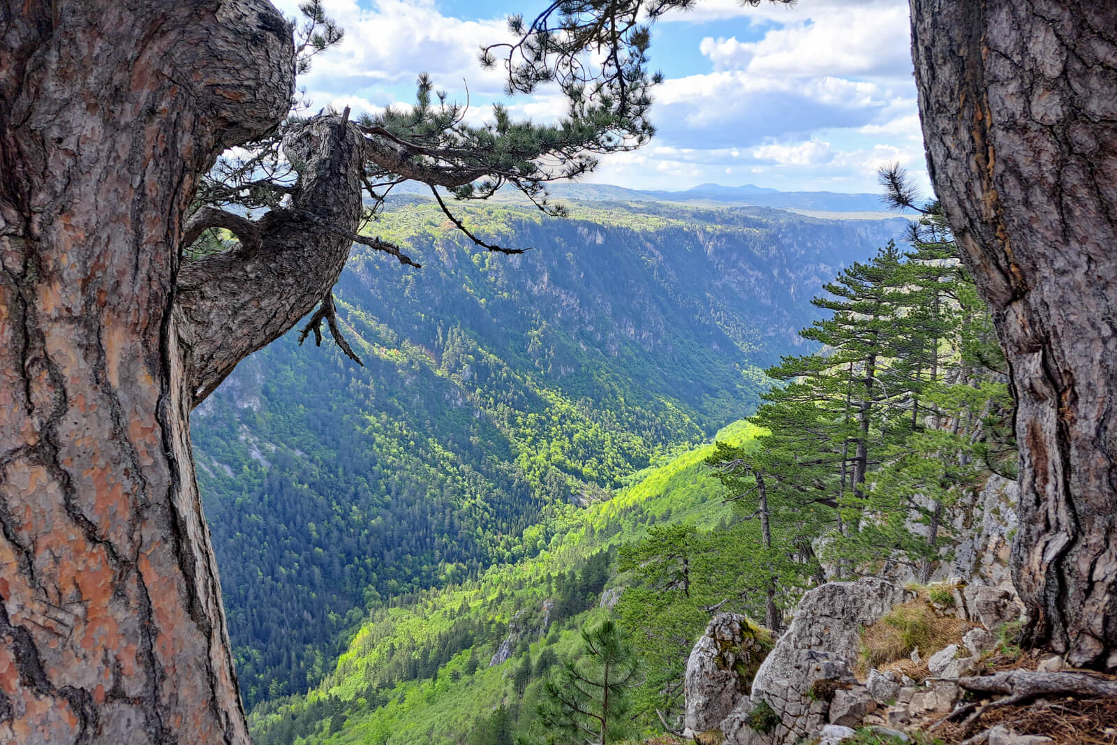
Montenegro’s section of the Trans Dinarica Cycle Route is as epic as one might expect. The route crosses the border from Bosnia and Herzegovina along the Tara River. The Tara River Canyon is considered the deepest canyon in continental Europe, at its highest point it is 1,300 meters deep. From there the route traverses the UNESCO-inscribed Durmitor National Park before heading south deep into the Prokletije Mountains near the Albanian border.
As you move south, the route gives you options. Cyclists can either head into Albania and into the “Albanian Alps” or pedal towards the capital city of Podgorica; for easier logistics or a more flat road connection with Albania, to the city of Shkodër on Lake Skadar.
Highlights along the Trans Dinarica in Montenegro:
- Take a plunge in the Tara River Canyon.
- Enjoy the UNESCO-inscribed Durmitor National Park.
- Cycle beneath the jagged peaks in Prokletije National Park.
- Eat and drink well in the capital city of Podgorica.
- Visit the largest lake in the Balkans: Skadar Lake National Park.
Map of Trans Dinarica in Montenegro
Video about Trans Dinarica in Montenegro
Trans Dinarica Montenegro Gallery


Ready to get navigation/information pack?
Navigation PackMain Route of Trans Dinarica in Montenegro
Stage 1: Šćepan polje - Trsa
 Distance:
34 km
Distance:
34 km Elevation:
1.310 m
Elevation:
1.310 m Paved:
100%
Paved:
100% Unpaved:
0%
Unpaved:
0%The first cycling stage into Montenegro from Bosnia and Herzegovina takes cyclists to one of the most beautiful sections of the entire Trans Dinarica Cycle Route. This day begins from Šćepan Polje, along the border, and ends in the town of Trsa, east of the Piva River, which turns into the Piva Lake, and near the western edge of the UNESCO-inscribed Durmitor National Park.
Today’s bike ride, which is all asphalt, starts with a big climb for about 16.5 kilometers and then turns into a fairly level, but rolling, ride for approximately 20 kilometers until the stage’s end in Trsa. Warning: when crossing border, first you will cross the Bosnia and Herzegovina border before the bridge over the Tara River, then you must turn right across the bridge and check at the Montenegrin border control. Only then can you legally turn 180 degrees and choose a side road – from this side you will turn right just before the bridge. Welcome to Montenegro!
After a scenic riding day you’ll end in Trsa, where you’ll find some traditional Katuns (mountain houses) in a village framed by the Dinaric Alps. Please note that outside the main tourist season, many of these accommodations are closed and the information is not always up-to-date.


Stage 2: Trsa - Žabljak
Distance:
40 kmElevation:
870 mPaved:
99%Unpaved:
1%This stage on your Montenegro cycling tour on Trans Dinarica is one of the most visually stunning of the entire 5,000-plus-kilometer route. Leaving from Trsa you will immediately be riding on great asphalt among tall peaks.
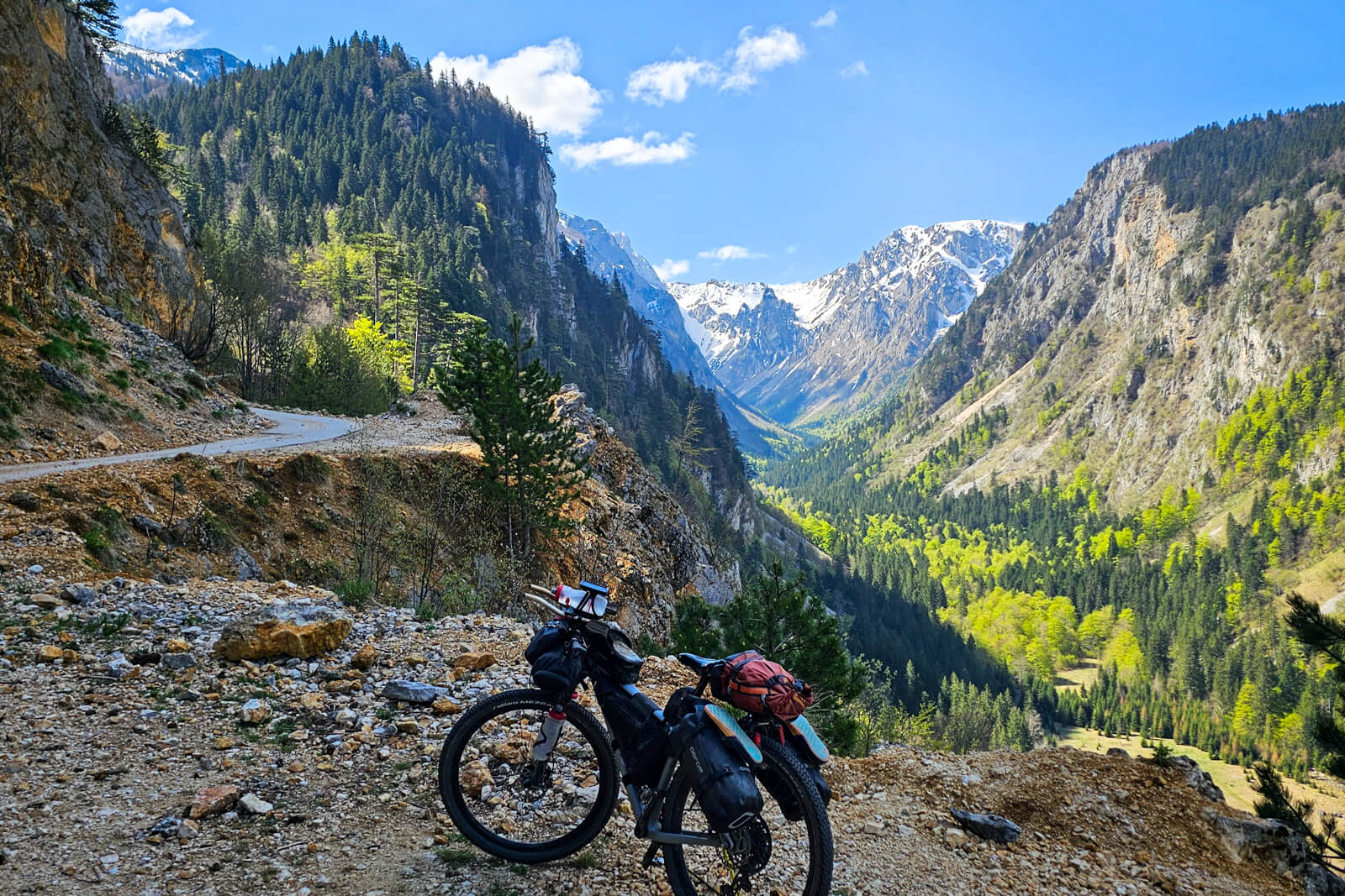
Taking the southern route under the 2,523-meter Bobotov Kuk, the tallest peak along the Durmitor Massif, from Trsa to Žabljak, cyclists will tackle multiple climbs that average about 6% grade. The payoff is immediately obvious. Not only is the scene around you more magnificent with every hilltop, but there are designated view points to rest, take pictures, and absorb the magnificence of Durmitor National Park. It is worth noting that in July and August the road can be quite busy; you will meet hikers who want to get as close as possible to the starting points for mountain climbing by car, motorcyclists and travellers who sometimes take their oversized campers onto the narrow road. Rise with the sun early in the morning, and while everyone else is sipping their coffee, you will be soaking up the sun’s rays in the heart of Durmitor. Another warning: this pass can be closed due to snow until May, although recent years of mild winters have allowed riding as early as April. Similarly, snow can surprise you in early autumn. These are real mountains, not a funfair!
Two highlights along the way are the 2,393-meter Mount Prutaš, which rises right next to the road, and the Sedlo Pass, in the heart of the national park. After the pass, cyclists are rewarded with 20 kilometers of descent and easy riding into the town of Žabljak, the final destination.
Žabljak is one of those destinations that it’s a shame to leave after just one night. Many cyclists take their luggage off their bikes and ride the 76-kilometer Durmitor Ring, or just part of it, to the village of Mala Crna gora (before riding town to ‘Sušičko jezero’ lake, which is dry after June), for example.


Alternative suggestion:
Trsa – Sušica river Canyon – Žabljak
- Distance: 39 km
- Elevation: 1.150 m
- Paved: 100%, unpaved: 0%
The main stage from Trsa to Žabljak is one of the most beautiful on the entire Trans Dinarica, but since it climbs to 1,907 meters above sea level and lies in the heart of the Durmitor Mountains, it is possible that the route will be closed due to snow in spring (like in May 2026, when we are publishing this alternative route). Don’t worry, this alternative suggestion is not much less picturesque (if at all), as it leads through the canyon of the Sušica River, at the bottom of which lies an intermittent Sušica Lake (somewhere by June there will be a lake, later a beautiful green meadow). The stage itself has similar characteristics (length, elevation gain) as the original one, except that instead of going uphill, you will first descend into a steep canyon and then cycle out of it (if you don’t have a ‘granny’s gear’, you will probably have to get off your bike at times). The road is narrow but completely paved; as the main route’s road over Sedlo, it can be busy in high season (July, August). There are even some accommodations available before entering the canyon (see POIs in the navi pack), which means that on the way from Ščepan Polje (stage 1 in Montenegro) you can also avoid cycling to the village of Trsa; otherwise, you will have to cycle 3,5 kms back on the same road to the turnoff for the canyon.
Stage 3: Žabljak - Kolašin
Distance:
70 kmElevation:
1.060 mPaved:
78%Unpaved:
22%The ski resort town of Žabljak is an excellent place to take a break for a day to do some shopping, make any necessary repairs, explore Durmitor National Park, have a few nice meals, and get a good night or two of sleep. The town, which has cafes, accommodations, tourism operators, bars, and restaurants is quickly being discovered by adventure travelers.
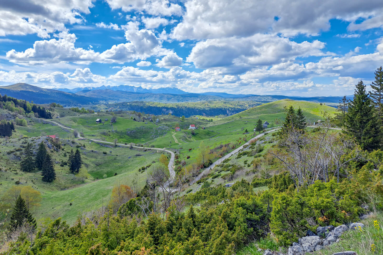
The first part of the stage is relatively easy and follows a pleasant asphalt road. After the route leaves the R18 road, the Trans Dinarica demands more work from you: first with a steep asphalt climb, and then with a longer section on not-so-perfect gravel road. Those with fully loaded bikes will probably have to get off the bike at times. On the stretch from the picturesque St. Archangel Michael Church to the serpentine descent into the valley of the Ropušica river, you will cycle along a dreamy mountain plateau, exposed to incredible views, but also to mountain weather conditions. As we were able to learn from cyclists, all restaurants and accommodations are closed early in October, and after heavy rains there are deep puddles on the road. Out of season and in bad weather, this section is only for the bravest and most technically and physically prepared. A slightly more accessible alternative is to stay on the R18 road, but even here you will encounter a steep climb and descent, and at the end you will drive on the main road (E65).
After descending into the valley towards the village of Gornje Lipovo from the Sinjajevina plateau, you can again expect some civilization and possibilities for accommodation. This part of the stage is especially challenging if you tackle it in the opposite direction – from Kolašin towards Žabljak.
Today’s stage along the Trans Dinarica bike trail in Montenegro takes cyclists to ski town Kolašin. Sitting on the banks of the Tara River with the Kolašinska River running through it, Kolašin is a beautiful spot to stay while investigating the 56.5-square-kilometer Biogradska Gora National Park, which is on UNESCO’s tentative list. Important when planning logistics: you can get to Kolašin from Podgorica by train (or vice versa). As cyclists have told us, they also take their bikes on the train, making the ride fast and cheap.


Stage 4: Kolašin - Štavna
Distance:
32 kmElevation:
910 mPaved:
100%Unpaved:
0%Today’s stage along Montenegro’s section of the Trans Dinarica Cycle Route leaves from the ski resort town of Kolašin. Kolašin sits on the banks of the Tara River with the Kolašinska River running through it. This town is also a perfect headquarters for investigating the 56.5-square-kilometer Biogradska Gora National Park.
The ride today will be dominated by a another climb. For approximately the first 10 kilometers, the road will follow the Tara River. At the village of Mateševo, the angle of the road and the river will change. From here, the route will follow the Drcka River and will tilt gradually up for the rest of the climb.
The stage’s terminus will leave cyclists at the beautiful and remote Etno Selo Štavna, where cozy mountain huts are surrounded by peaks. Adventuring travelers here will feel the area’s embrace through its inviting landscape, great food, and hospitality as beautiful as they will experience along the route. It is worth adding that these mountain huts are only open during the season, from May to September; outside of this time, a warm bed and hot soup will be easier to find in nearby Andrijevica, to which you can also descend on the main road M9.


Stage 5: Štavna - Gusinje
Distance:
55 kmElevation:
630 mPaved:
83%Unpaved:
17%One of the aspects that draw cyclists to travel the Balkans is its diversity … and the Trans Dinarica is nothing if not diverse both culturally and geographically. Fans of this diversity will not be disappointed as they leave from the remote Etno Selo Štavna, where cozy mountain huts are surrounded by peaks. Adventurers will feel the area’s embrace through its inviting landscape, great food, and hospitality as beautiful as they will experience along the route.
Two stages away from the Albanian border, the beginning of this day is defined by its rapid descent in the first 15 kilometers, which rolls across a combination of paved and unpaved roads. (If the gravel descent proves too challenging, consider taking the all-asphalt alternative on M9, especially when riding in the opposite dirrection.) Riders will soon pass through the small and pleasant town of Andrijevica. The route parallels the western side of the Lim River before crossing to the river’s eastern bank. The trail takes back to the western side at the village of Murino and continues for the next 10 kilometers until Lake Plav, Montenegro’s biggest glacial lake and one of the region’s highlights.
From Plav, the Trans Dinarica travels along a road with moderate traffic through villages. The path maintains an elevation of around 925 meters with mountains soaring to the south and National Park Prokletije just within reach. The stage’s end leaves riders in Gusinje, at the confluence of staggeringly stunning river valleys.
Important notice: If you plan to use the connecting stage Peja (Kosovo) – Gusinje (Montenegro), please note that the road leads through an unofficial border crossing closed to traffic. Before crossing this border, you must register at the local police station in Peja (if you’re traveling from the direction of Kosovo) or at Border Police Station near Plav (Montenegro) at least 24 hours before the intended crossing. The border crossing permit should be arranged via email (10 days in advance!), information on the email address can be found on the Peja Tourism website.


Secondary routes of Trans Dinarica in Montenegro
Stage 6: Kolašin - Podgorica
Distance:
75 kmElevation:
810Paved:
99%Unpaved:
1%This “alternate” bike stage on the Trans Dinarica from the town of Kolašin in Montenegro to Podgorica is perhaps reason enough to consider this cycling route. This section provides a scenic and convenient way to access the Montenegrin capital straight away, while also enjoying great cycling.
The bike trail first passes through the village of Mateševo, where this and the route head into the Prokletije Mountains and then the Albanian Alps divide. You’ll turn west. About a third of the way into the ride — at approximately the 25-kilometer mark — you will pass the village of Veruša. From here, the route heads straight through the peaks of Dinaric Alps and passes by Komovi Nature Park.
Soon after, the route follows the Mala Rijeka (Little River) as it continues its long descent toward its final stop: Podgorica. Among the highlights is the fantastic bridge across the Mala Rijeka — the highest railway bridge in Europe and the second in the world (200m). Soon after, the Mala Rijeka merges with the Morača River, where the route is cradled by the show-stopping Morača Canyon.
The traffic picks up a bit as the route stays on excellent asphalt entering Podgorica. As a welcome to the capital, find one of the many restaurants in the city and toast your fellow riders on a stage well ridden.
If you’re in a hurry to catch a plane or the weather is bad, there is a train running between Podgorica and Kolašin that also takes bicycles.


Stage 7: Podgorica - Shkodër (Albania)
Distance:
62 kmElevation:
420 mPaved:
100%Unpaved:
0%The Montenegro bike tour of Trans Dinarica continues its alternative path to and through Podgorica, the Montenegrin capital, with a relaxed ride south along the shore of Lake Shkodër and across the border into Albania. This stage’s path rolls over gradual ascents and descents on completely paved surfaces. Don’t expect spectacular views, but above all a quick and easy connection to the Albanian part of the Trans Dinarica.
For the first four kilometers after exiting Podgorica, there is a new, nice bike path. It goes to the bridge over the Cijevna River. From here, one can peek into the river’s extremely narrow canyon. Cyclists will then follow around four kilometers of a straight stretch with more traffic. At the village of Tuzi the stage turns onto a quiet side road with very good asphalt, that slowly climbs towards border crossing. Once over the border, the route pedals about halfway along Lake Shkodër past the village of Koplik.
The day ends in the dynamic and adventure-loving town of Shkodër, the unofficial capital of northern Albania. It is certainly worth spending a day or two here to refuel, restock, and to take in loads of cultural offerings such as the Marubi National Museum of Photography.


Do you support sustainable travel?
Support SustainabilityUseful information about logistics in Montenegro
- Capital: Podgorica
- Language: Serbian (English and Russian are often spoken in touristic cities)
- Currency: Euro (prepare yourself to have enough cash – it’s not always possible to pay with credit card)
- Driving side: right
- Calling code: +382
- Emergency numbers: Police: 122, Firefighters: 123, Ambulance: 124, Help at sea: 129, Unique European emergency number: 112
- The biggest towns close to Trans Dinarica: Žabljak, Mojkovac, Berane
- Airports: Podgorica, Tivat, and Tirana (Albania)
- Buses in Montenegro
- Trains in Montenegro
- Taxis in the capital: PG Taxi 19704, Naš Taxi 19709, E Taxi 19789, Lider 19775
- Ferry/catamaran: Budva- Dubrovnik (Croatia) and Bar- Bari (Italy)
- Popular cruise locations: Skadar Lake National Park and Bay of Kotor
- National tourist organization
Montenegro is a hidden gem for cycling enthusiasts, particularly those looking to explore the stunning Trans Dinarica route. To get to Montenegro, tourists can fly into the country via Podgorica or Tivat airports, or opt for Tirana, Albania, which is a viable alternative. Upon arrival, renting a car or utilizing local transport services can help you reach key towns close to the Trans Dinarica route, such as Žabljak, Mojkovac, and Berane. These towns serve as excellent starting points for your cycling adventure. For those arriving by sea, there are convenient ferry and catamaran connections, such as the Budva to Dubrovnik (Croatia) route, and the Bar to Bari (Italy) route. Montenegro’s stunning landscapes aren’t limited to its inland routes; popular cruise locations like Skadar Lake National Park and the Bay of Kotor offer breathtaking scenery and opportunities for relaxation after your cycling excursions. Whether you arrive by air, land, or sea, Montenegro promises a memorable experience.
Getting around by land:
While buses are a common mode of transport, their punctuality can be quite unreliable, especially during the high tourist season in summer. The southern part of the country often experiences traffic jams, leading to delays. Despite this, buses remain a viable option for budget travelers who can afford a bit of flexibility in their schedules.
Taxis present a more dependable alternative, especially in the capital city of Podgorica and the northern regions. In these areas, taxis are relatively affordable, providing a convenient means of transport for tourists. However, in the coastal part of Montenegro, taxi services tend to be more expensive due to higher demand during the tourist season. Nonetheless, for short trips or when punctuality is crucial, taxis are a practical solution.
For those interested in train travel, Montenegro offers a scenic yet often unpredictable experience. The train network connects Podgorica to several key locations. The coastal town of Bar can be reached via a train that makes a stop in the charming fishing village of Virpazar. In the north, the train route extends to Bijelo Polje, with stops in Kolašin (that’s on the route) Mojkovac, providing access to some of the country’s most beautiful landscapes. Another route from Podgorica heads to Nikšić, stopping in Danilovgrad. Though the trains are not always on schedule, they are an economical way to travel and offer some of the most breathtaking panoramic views in Montenegro, making the journey itself a memorable part of the adventure.
Important notice: If you plan to use the connecting stage Peja (Kosovo) – Gusinje (Montenegro), please note that the road leads through an unofficial border crossing closed to traffic. Before crossing this border, you must register at the local police station in Peja (if you’re traveling from the direction of Kosovo) or at Border Police Station near Plav (Montenegro) at least 24 hours before the intended crossing. The border crossing permit can be arranged via email (10 days in advance!), information on the email address can be found on the Peja Tourism website.
Ready to get navigation/information pack?
Navigation PackYou might also like ...


Feeling overwhelmed with travel planning?
Leave this time-consuming and stressful task to professional tour operator companies that we suggest and just enjoy the tour.
Ask a professional