Countries
North Macedonia
No. Stages
7 stages
Length & Elevation
406 km, 6.340 m
Paved
93%
Unpaved:
7%
Trans Dinarica in North Macedonia
One of Europe’s most complete adventure destinations, North Macedonia combines world-class national parks, UNESCO sites, mountains, lakes, and undoubtedly some of the best food in the region. Cyclists who are lucky enough to pedal here will enjoy the full power of the Balkans, where ancient cultures intersect in perched, remote, centuries-old, welcoming villages nestled under peaks.
Underrated as a cycling destination, every kilometer in North Macedonia is like a dream. Cyclists enter the country from Albania on the Ohrid Lake (on the main route) or near the tri-border spot with Albania and Greece on the Prespa Lake (on the secondary route). Then they weave between world famous lakes. After, they roll along the foothills of mountain range after mountain range — drinking and eating as well as anywhere along the entire route. The Trans Dinarica makes stops in Lake Ohrid, Galičica National Park, Bitola, Mavrovo National Park, and the Šar (Sharr) Mountains, but there is much more to see than just the famous destinations. The towns and villages like the remote Galičnik and Kruševo, with its Ilinden monument called Makedonium, will amaze travelers at every turn.
If you’re tempted by harder, more adventurous stages, look out for the three secondary stages for North Macedonia; one takes you from Kičevo to Galičnik and Mavrovo, and two along the ‘water route’ to Popova Šapka and the Lešnica valley. We recommend all three only to experienced cyclists who don’t mind the occasional hike&bike section.
Highlights along the Trans Dinarica in North Macedonia:
- Cycling around Lake Ohrid, a UNESCO World Heritage Site.
- Take incredible photographs in the foothills around Galičica National Park.
- Eat superb food and enjoy the old town in Bitola.
- Roll through the incredible culture-filled villages of Galičnik and Kruševo.
- Ride in awe as you pedal beneath the peaks of the Šar (Sharr) Mountains.
Map of Trans Dinarica in North Macedonia
Video about Trans Dinarica in North Macedonia
Trans Dinarica North Macedonia Gallery


Ready to get navigation/information pack?
Navigation PackMain Route of Trans Dinarica in North Macedonia
Stage 1: Ohrid - Sveti Naum
 Distance:
31 km
Distance:
31 km Elevation:
510 m
Elevation:
510 m Paved:
100%
Paved:
100% Unpaved:
0%
Unpaved:
0%The first full stage of North Macedonia’s section of the Trans Dinarica Cycle Route is also one of the most culture-filled of this entire Western Balkans bike trail and a highlight of bike touring in the Western Balkans. The bike trail starts on the eastern shores of the UNESCO-inscribed Lake Ohrid, and will go to Sveti Naum, which is an important sightseeing spot, before coming back about three kilometers to stay in the village of Lubaništa for accomodation.
A highlight on any journey to the region, the tectonic Lake Ohrid, one of the oldest and deepest lakes in Europe, is rare in the fact that it was inscribed as a UNESCO site for both natural and cultural reasons. Take the time to visit one of its many historic churches, eat some of the best fish and vegetable spreads you’ve tried in a while, and toast your fellow cyclists with a glass of local wine to celebrate cycling into North Macedonia.
Though the length of kilometers makes this stage from Ohrid to the must-see lakeside monastery of Sveti Naum seemingly short, it will be a full day because of the time travelers will likely take to visit the site. From Ohrid the route hugs the lake’s eastern shore and along the western side of the magnificent and hilly National Park Galičica.
The cycle path will make three real climbs and descents on the way to Sveti Naum Monastery, which dates to the 9th century and has been rebuilt multiple times over the centuries. After visiting the monastery, have a meal and relax in one of the restaurants in and around the complex.
It might be worth mentioning that after leaving Ohrid, don’t expect any shops on the way to Bitola. In between, you’ll have a tough climb over Galičica, so be sure to pack an extra snack.


Stage 2: Sveti Naum - Bitola
Distance:
78 kmElevation:
1.290 mPaved:
94%Unpaved:
6%This stage along the Trans Dinarica from the Sveti Naum Monastery complex (or staying in the village of Lubaništa) will take cyclists to the road leading to the entrance of National Park Galičica. Then, the cycle route takes travelers to the beginning of a long climb that covers more than 13 kilometers and ascends for approximately 700 meters of elevation gain to the top of the mountain. The grade will remain consistent and fairly gentle at about seven percent. If you’re cycling in early spring or late fall, expect a big change in temperature. Be prepared for the (bad) weather; also, there are no shops or restaurants across the pass.
There are fantastic views throughout this second Trans Dinarica stage in North Macedonia. The 14-kilometer downhill portion to Lake Prespa provides both great and easy riding and more wonderful views. Located at the tri-border point between North Macedonia, Albania, and Greece, cycling to this magical corner of the Western Balkans puts travelers squarely in the middle of National Park Galičica, Prespa National Park, National Park Pelister, Lake Prespa, and Lake Ohrid.
The first half of the stage passes through the village of Pokrvenik near the edge of Prespa Lake in the southwest corner of North Macedonia. In Pokrvenik, there are accommodation possibilities for those wishing to stop a little earlier on this slightly longer stage. After, it continues on to its final destination: the city of Bitola, one of the oldest and largest cities in the country.
Bitola is famous for its ancient culture and its wonderful food. It is also one of the most pleasant spots in the region and a wonderful place to rest for the night, have a great meal, visit the outdoor green market, and take in one or more of the museums. The highlights in town include Širok Sokak Street, the city’s walking and shopping avenue; the ruins of Heraclea Lyncestis, which was established by Philip II of Macedon; the Bitola Clock Tower; and the Bitola Museum.


Stage 3: Bitola - Kruševo
Distance:
51 kmElevation:
800 mPaved:
94%Unpaved:
6%This stage along North Macedonia’s section of the Trans Dinarica Cycle Route passes from one important city to an important town. From Bitola, you ride through the village of Buchin and then to the town of Kruševo. For most of today’s ride the route is relatively — if not completely — flat. Don’t worry, you’ll make up for it at the end of the ride. The last 10 kilometers, approximately, combines steady climbing and, at times, quite steep terrain with a grade ranging from around four to 14 percent.
The reward for the final climb of today’s bike trip is Kruševo, which is one of the highest towns in the country (around 1,350 meters) and the region. Many associate the town with paragliding and a significant number of adventure travelers make the pilgrimage here every year to glide above the beautiful countryside. At the perched town’s center is a welcoming combination of shops, cafes, and restaurants. Perhaps the most famous site in Kruševo is the Ilinden Monument: a science-fiction-like monument built in 1974 to honor the 1903 Ilinden Uprising.


Stage 4: Kruševo - Kičevo
Distance:
59 kmElevation:
780 mPaved:
88%Unpaved:
12%The Trans Dinarica leaves Kruševo and heads west to the city of Kičevo. With Mount Bistra and Mavrovo National Park further to the northwest, cyclists will find beautiful asphalt and a stage drawing them closer to the Šar (Sharr) Mountains.
The stage begins with immediate climbing on quiet roads leading to a five-kilometer descent before another climb and descent. Along the way, cyclsits will ride on the only gravel area of the day — an approximately seven-kilometer stretch in the first third of the ride. The rolling hills continue until about 30 kilometers into the stage, which finishes on the stage’s second half (over the last 30 or so kilometers) with an easygoing downhill ride or on flat land.
In Kičevo, find a place to eat, restock on supplies and check out the cultural offerings. Among the sites worth a closer inspection: the Western Macedonian Museum, the Monastery of St. Bogorodica Prečista, and the city’s central bazaar.


Stage 5: Kičevo - Mavrovo
Distance:
63 kmElevation:
1.300 mPaved:
100%Unpaved:
0%Today’s stage continues to the north and west from the city of Kičevo to the mountain village of Mavrovo, which sits in the foothills of the Bistra Massif, on the shores of Mavrovo Lake, and in Mavrovo National Park.
For much of the day, the route, which is around 63 kilometers and entirely paved, will climb steadily and gently. You’ll pass through pretty and sleepy settlements such as Crvica, Kolibari, Grešnica, Zajas, Kolari, and Sretkovo as you make your way to the eastern coast of Mavrovo Lake. At this point, the road, level and flat, heads southwest along the lake’s shore. We must point out, however, that part of the stage you will cycle on the main road (E-65), which can be quite fast and busy. The alternative is the gravel stage directly towards Galičnik (but this one is very demanding) or you can try to find a local transfer to the crossroad from the main road towards Mavrovo Lake.
A popular place all year round, Mavrovo is famous for its lake, naturally, but also for great skiing. As well, there are churches and many restaurants and accommodations. Though Mavrovo is the suggested end of today’s stage — because of the wide selection of sleeping and dining options — there is a possibility of adding an additional section to the day’s stage.
On Lake Mavrovo’s southwestern shore, a sign will take you to the road for the village of Galičnik. Here, the route tilts up with an exhilarating climb that is, at times, quite steep (more than 12 percent). In Galičnik, which only has two year-round residents, cycle through the homes (many renovated) that sit on the edge of a canyon. Admire the church and the great views. If you are cycling in July, be sure to stay for the famous Galičnik wedding weekend in which two new people with ancestral connections to the village are married with all the traditional ceremonies.


Suggested accomodation:
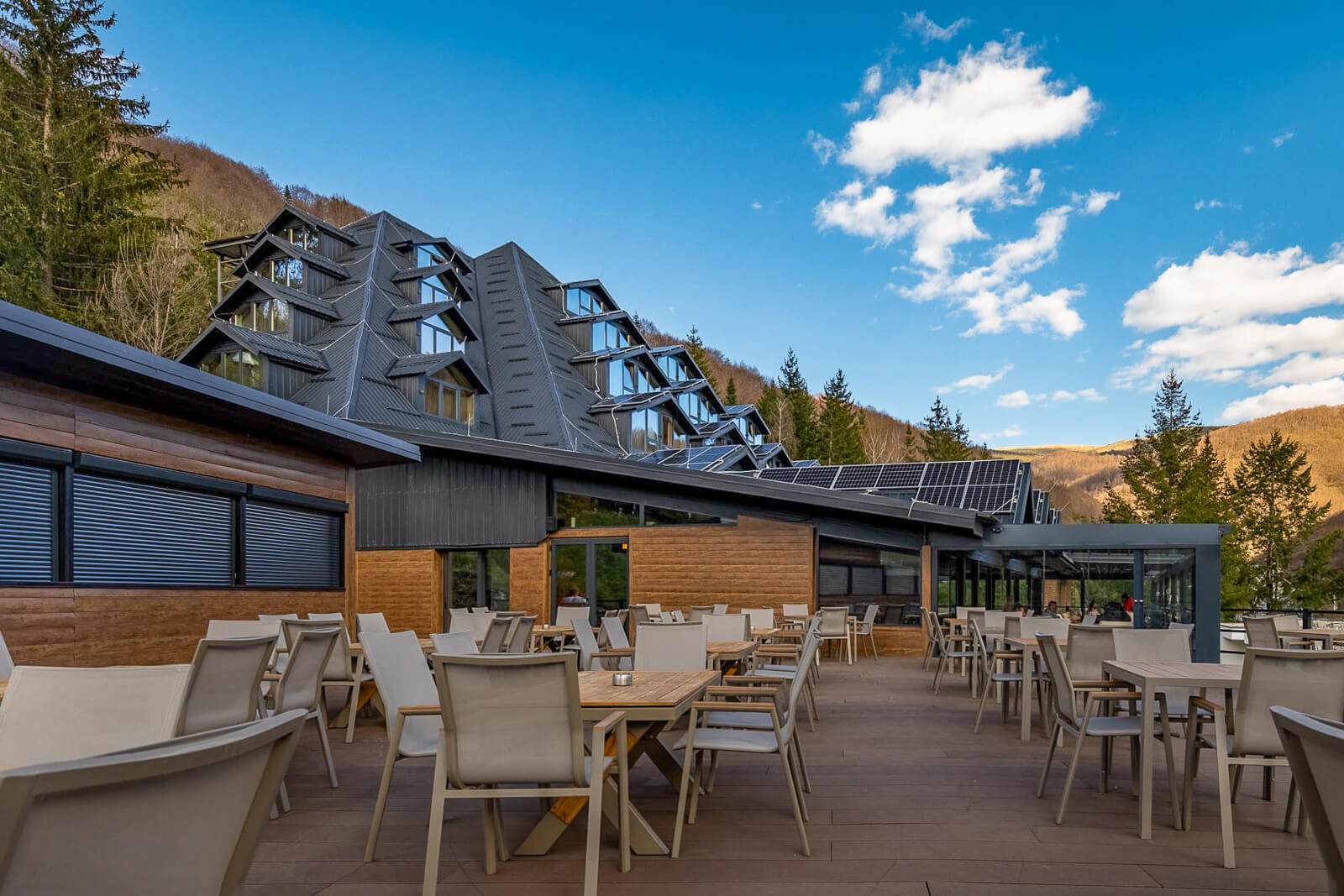
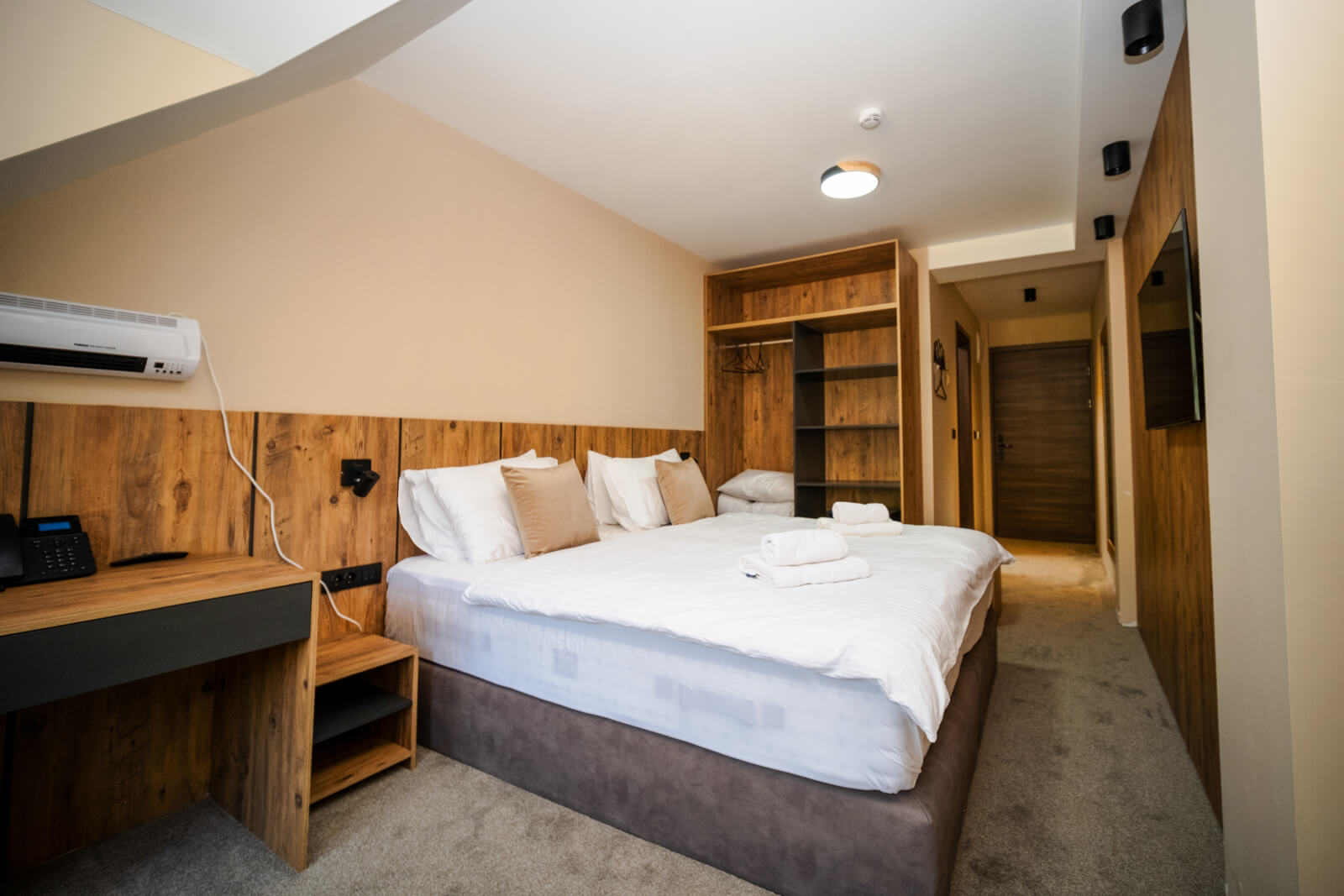
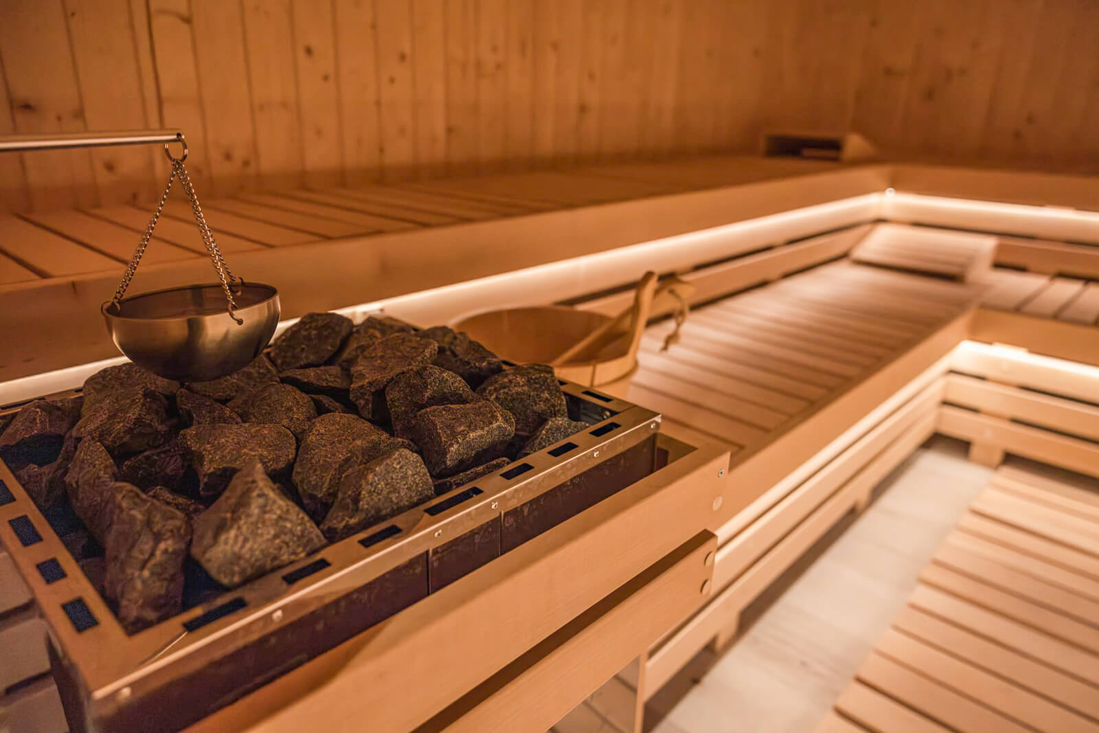
Grand Chamois Hotel
Grand Chamois Hotel is located on the southern side of the Mavrovo lake, just 1,5 km from the famous sunken church. It is a cyclist-friendly hotel with a secure garage (and e-bikes charging), a relaxing sauna or ice bath for tired cyclists, and its own a la carte restaurant, offering everything from burgers and pizza to special local dishes. After all the hard pedaling, you can treat yourself to a little pampering – and the prices in Grand Chamois Hotel are actually very affordable (the photo shows an ‘economy’ room). When making a reservation, say that you are a ‘Trans Dinarica Traveler’ and you will be granted a 10% discount. Another tip: this hotel is great for those who came to Mavrovo via the main TD route from Kičevo and would like to make a day trip to the village of Galičnik (which we definitely recommend – see secondary stage TD-MCD-08_Kicevo-Galicnik-Mavrovo). website / facebook / instagram
Stage 6: Mavrovo - Tetovo
Distance:
55 kmElevation:
350 mPaved:
78%Unpaved:
22%From Mavrovo, the Trans Dinarica hugs Lake Mavrovo’s western shore. The cycling will be flat for the first nine (approximately) kilometers of the 55-kilometer stage. While riding, with the lake to the right, cyclists will have views of the 2,764-meter Mount Korab, on the Albanian border and the highest mountain in this immediate region of the Western Balkans.
After the lake, the route becomes unpaved, and slightly descending. For an eight-kilometer section, from around the 10.5-kilometer mark until 18 kilometers, the route becomes a fun change of pace from asphalt motorways.
Rolling north, riders will soon be engulfed by the Šar (Sharr) Mountains. Villages — such as Rechane, Vrutok, Raven, Zdunje, and Kamenjane — will be continual. These settlements have, of course, cafes, restaurants and places to stop for drinks, supplies, and food. Approximately halfway along the stage, the route largely flattens out. Before ending the stage in the city of Tetovo, the Trans Dinarica will run along the edge of National Park Šar Mountain.
If you would rather cycle through wild nature than through populated areas, consider the alternative stage Mavrovo – Popova Šapka. But as you can read in the description, this section is only intended for well-prepared adventurers who don’t mind the fact that they will probably encounter more bears than cars on the stage.


Stage 7: Tetovo - Brezovica (Kosovo)
Distance:
70 kmElevation:
1.300 mPaved:
100%Unpaved:
0%The last day of cycling the Trans Dinarica in North Macedonia leaves from the city of Tetovo and travels north to Kosovo and the town of Brezovica, one of the best-known ski resorts in the region.
Before leaving Tetovo, take some time to enjoy this city in the foothills of the Šar (Sharr) Mountains. Famous as a place to start adventures in the mountains and just 20 kilometers from the ski resort village of Popova Šapka, it is also filled with cafes, restaurants, and points of interest such as the Painted Mosque (Sharena Dzamija), the dervish monastery of Arabati Baba Tekke, and the Tetovo Fortress.
From Tetovo, the ride (completely on asphalt) climbs easily, but steadily, for almost 40 kilometers to an elevation of around 1,100 meters. Along the way, you’ll cross the border into Kosovo (at approximately kilometer 28), cycle past the perfectly pointy, 2,498-meter Mount Ljuboten, and ride through the Kosovo mountain village of Brod. After reaching the top of this gradual climb, the road tilts down for about 10 kilometers of relaxed descent. You will, however, ascend again — this time even more gradually — for the remainder of the ride into Brezovica.


Secondary routes of Trans Dinarica in North Macedonia
Stage 08: Kičevo - Galičnik - Mavrovo
Distance:
68 kmElevation:
2.020 mPaved:
49%Unpaved:
51%This stage, which might look like a more direct connection to Mavrovo on the map, is recommended for more adventurous cyclists. The forest path on the way up is partly dirt, which can turn into slippery mud in the rain, and there are no settlements along the entire stage where you can get refreshments or seek shelter in case of bad weather. It takes you to the north and west from the city of Kičevo to the mountain village of Galičnik, which sits in the foothills of the Bistra Massif and in Mavrovo National Park.
A fair portion of the day will be spent climbing and on gravel. More than 50 percent of today’s stage will be unpaved. For the most part, the cycling here is steady. There are, however, a few spots steep enough to potentially require pushing your bike for a few hundred meters. Not to worry. The descents are smooth and allow you to recover and watch as the landscape unfolds across one of the most interesting parts of the region: where Mount Bistra, the Šar (Sharr) Mountains, Korab all converge around Mavrovo National Park.
When you reach asphalt again, with approximately 10 kilometers to go, you’ll reach a junction connecting the town of Galičnik and Mavrovo. (Both are 10 kilometers away — in case some cyclists want to ride directly to Mavrovo.) Take the left heading to Galičnik. This new road winds around with beautiful climbs and sweeping descents.
In the village of Galičnik, which only has two year-round residents, cycle through the homes (many renovated) that sit on the edge of a canyon. Admire the church and the great views. If you are cycling in July, be sure to stay for the famous Galičnik wedding weekend in which two people with ancestral connections to the village return to the Galičnik to be married with all the traditional ceremonies.
Following your visit in Galičnik, you’ll cycle 10 kilometers back the way you came to the junction. This time, take the direction toward Mavrovo and enjoy an incredible, flowing ribbon of asphalt that will take you 10 kilometers all the way down to Lake Mavrovo. Due to the tourist infrastructure, this is a better option for an overnight stay than Galičnik, where you need to be a bit lucky to find a free bed (and to successfully book in advance).


Stage 9: Mavrovo - Popova Šapka
Distance:
96 kmElevation:
2.210 mPaved:
15%Unpaved:
85%The “secondary” routes outlined here are often wilder and more challenging than the “main” route. The rewards: Breathtaking landscapes, solitude, and incredible mountains and picturesque valleys. This stage from Mavrovo to Popova Šapka, which extends for around 96 kilometers and is approximately 85 percent unpaved, is a perfect example. Epic and demanding would be two good descriptors … unforgettable would be another.
At around 20 kilometers into the ride, near Vrutok and just above the source of the Vardar River, you’ll head north and west on gravel and unpaved surfaces and on a steady climb instead of continuing along the road on the “main” route through the valley toward Gostivar and Tetovo. The rest of the day will roll across unpaved and gravel surfaces.
The climb will reach approximately 1,300 meters of elevation. This marks the start of the so-called “Vodni put” (“Water Route”), which spans over 50 km of relatively flat terrain, following the contour line and crossing numerous valleys and streams (with water typically available even in summer). It also includes two unlit tunnels. Along this section of the route, there are a few individual accommodations available (a mountain lodge and private cabins), but they are not open regularly. It is, therefore, essential to check in advance whether staying at these locations is possible.
Above the village of Novo Selo, the flat “Water Route” ends, and a challenging climb of four kilometers with 500 meters of elevation gain begins. The surface is rough, with poor gravel roads and steep gradients, making it demanding for gravel bikes. With loaded bikes, pushing may be required in places. However, the views across the grassy plains and peaks of the Šar (Sharr) Mountains become increasingly spectacular.
The trail levels out toward the end, with some descents, passing shepherd’s pastures before reaching Popova Šapka. A truly epic stage, it is filled with long and steep climbs, encounters with wildlife, horses, sheep, and shepherd dogs.
It is important to note: Before this long and demanding stage, check the weather forecast so that you are not in the middle of the wilderness looking for shelter under spruce trees or in abandoned shepherds’ huts. As well, please take close notice of the challenging sections marked (and described) here in this navigation package — with warning points (POIs) on the tracks.


Stage 10: Popova Šapka - Lešnica Valley - Tetovo
Distance:
47 kmElevation:
670 mPaved:
50%Unpaved:
50%Another epic day, with an additional “secondary” option before descending back to Tetovo, created for the updated version of the Trans Dinarica Cycle Route. This stage, which is about 50 percent unpaved and rolls for approximately 47 kilometers, keeps those adventurers in mind who are looking for extra challenges and incredible rewards.
After a short climb above Popova Šapka, expansive views open wide and immediately validate your decision to take the “scenic” version of the Trans Dinarica while here in the Šar (Sharr) Mountains. This ascent is followed by a demanding and adrenaline-filled descent into the wild Lešnica Valley. Note: This is almost MTB terrain, with sections of rough gravel roads, challenging for gravel bikes. Great caution and slow descending are required.
The route passes shepherd’s pastures, with towering peaks surrounding the valley, giving it an alpine feel. Due south of the route, the 2,747-meter Titov Vrv is a powerful presence and the highest peak of the Šar (Sharr) Mountain Range. At the bottom of the descent, a short detour to the Leshnica Waterfall is possible (approximately. 1.5 kilometers by bike and another 300 meters by foot). Please take note that all hazards, as well as the detour to the waterfall, are appropriately marked and briefly described here in the navigational pack with warning points (POIs) on the tracks.
The trail continues with a slight descent along the Bozovska River followed by a short and challenging climb to the village of Bezovce, where it connects to the paved road. From there, the Trans Dinarica takes a mostly paved descent with a few short climbs, passing villages such as Veshala, Brodets, and Shipkovitsa before reaching the main Tetovo – Popova Šapka road. The route then descends into the center of Tetovo.


Alternative suggestion:
Popova Šapka – Tetovo (direct)
- Distance: 20 km
- Elevation: 0 m
- Paved: 100%, unpaved: 0%
For those who want to take a break from challenging stages for a couple of days, there is an option for an easier, paved descent directly from Popova Šapka to Tetovo.
The 20-kilometer, entirely paved, winding road brings your descending skills into focus as you drop nearly 1,300 meters with nice views and speed to go along with the freedom of pedaling across the Western Balkans on the Trans Dinarica. On the way down, there are photo opportunities and several places to stop for coffee or a bite to eat.
Do you support sustainable travel?
Support SustainabilityUseful information about logistics in North Macedonia
- Capital: Skopje
- Language: Official language is Macedonian, and second official language is Albanian, other spoken languages are Turkish, Serbian, Bosnian, Romani etc. English is widely spoken in the main cities and tourist areas.
- Currency: Macedonian Denar, MKD (1 EUR is approx. 61.5 MKD). Cash is commonly used, and credit cards are accepted in most urban places, for rural areas you may need to have enough cash.
- Driving side: Right
- Calling code: +381
- Emergency numbers: Unified emergency number 112, Police 192, Fire Department 193, Ambulance: 194, AMSM – Road Service: 196
- The biggest towns close to Trans Dinarica in North Macedonia: Skopje, Tetovo, Gostivar, Kichevo, Debar, Ohrid, Struga, Bitola, Prilep, Krushevo.
- Airports: Skopje International Airport, Ohrid St. Paul the Apostle Airport, Prishtina International Airport (in Kosovo)
- Buses: Buses are generally reliable, and tickets can be bought online, at bus stations, or directly from the check taker.
- Railways: The railway service is not very frequent and mainly used for local travel. More information can be found here.
- Local tourism organizations: National Association of Tour Operators and Travel Agencies, Association of Tourist Guides of Macedonia, Macedonian Association of Tourist Guides and Companions, Macedonia Timeless
Transportation tips:
Planning to get around North Macedonia is relatively straightforward. International air connections to North Macedonia are primarily through Skopje International Airport, which offers flights to many European destinations. Low-cost carriers operate frequently, making air travel economical.
Buses and cars are common modes of local transport for travelers but also for regional connection to neighboring countries Albania, Kosovo, Serbia, Bulgaria, and Greece.
There are limited international train services to North Macedonia, primarily from Serbia and Greece. Train travel can be slower compared to buses and cars but offers a scenic route.
While planning your travel in North Macedonia, it’s good to keep in mind that public transport schedules may vary, and it’s advisable to check in advance or be flexible with your plans.
Taxis are widely available in cities and towns, are not expensive and you can contact them via phone, most of the call center personnel speak English. If you catch a taxi on the street, it’s advisable to agree on the fare before starting the journey or ensure the meter is running. A list of Taxi Companies can be approached here.
In the Trans Dianrica North Macedonia navigation package, we included one connector route: Skopje – Tetovo.
Ready to get navigation/information pack?
Navigation PackYou might also like ...


Feeling overwhelmed with travel planning?
Leave this time-consuming and stressful task to professional tour operator companies that we suggest and just enjoy the tour.
Ask a professional